The University of Bucharest, through the ArchaeoSciences Platform within the Research Institute of the University of Bucharest (ICUB), in collaboration with the Teleorman County Museum and the School of History, Archaeology, and Religion at Cardiff University (UK), has participated this year in research conducted in the vicinity of Poiana (formerly known as Flămânda), Ciuperceni commune, Teleorman County Romania.
These research activities were conducted under the auspices of the pilot project “Prehistoric (c. 9000-5000 cal. BC) Human-River Interactions in the Lower Danube Valley” undertaken by the Teleorman County Museum Romania) and the School of History, Archaeology, and Religion at Cardiff University (UK) between 2017 and 2019. The primary objective of this collaboration agreement was to lay the foundation for a potential future extended research project.
The starting point for this project was the research conducted in 2011 for the preparation of an archaeological study related to the Urban Planning Zoning (PUG) of Ciuperceni commune, which led to the identification of 26 sites (designated as FLM 001, FLM 002, FLM 003, etc.) with traces of habitation from various epochs (Paleolithic, possibly Mesolithic, Early Neolithic, etc.).
The current project is based on a multidisciplinary program that includes systematic research, geological surveys, mapping, GIS support creation, coring, and test excavations.
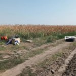
In this context, from August 23 to September 6, 2023, areas to the southeast, north, and southwest of Poiana were targeted, with a particular focus on archaeological sites FLM 024, FLM 025, and FLM 015, using non-invasive terrestrial and aerial means.
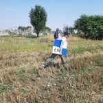
The research team involved in field and laboratory work consisted of researchers and archaeologists from ICUB (Cristina Covătaru, Adrian Șerbănescu, Cristian Roth), the Teleorman County Museum (Pavel Mirea), and the Cardiff University (Stephen Mills).
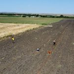
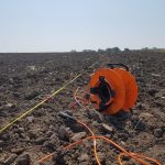
Electrical Resistivity Tomography (ERT) was employed among the terrestrial investigation methods. The investigation and mapping of surface stratigraphy through the measurement of soil electrical resistivity aimed to identify possible alluvial horizons with a high flint content originating from the Danube’s southern bank. Through other methods, these can potentially be correlated with human activity from the Paleolithic or Mesolithic periods.
Utilizing various platforms and sensors, we conducted a macro-scale analysis of the surrounding landscape using Unmanned Aerial Vehicles (UAVs). Aerial mapping of the areas of interest was accomplished through aerial photogrammetry using a DJI Phantom 4 Pro drone and airborne laser scanning technology (LiDAR) with the Trinity F90+ drone.
The areas of interest were documented to obtain new insights into changes in the surrounding landscape. Such an analysis, in conjunction with other non-invasive methods, can guide future archaeological research strategies.